Chapter 18: Hawaii

Hawaii has many volcanoes that are both active and dormant. Bay area residents believe that Mount Tamalpais, in Mill Valley, is a remnant of an extinct volcano. It is believed by geologist that Mount Tamalpais was created due to its location near the San Andres Fault. Over time the mountain has risen from the earth's crust, while erosion has only left solid rock exposed in the highest peaks and ridges.


Tourism is a big part of the economy in both Hawaii and San Francisco. In 2010, San Francisco was visited by 15.9 million visitors. These visitors spent up to 8.3 billion dollars at local businesses. People are drawn to visit San Francisco because it is frequently portrayed in music, film and popular culture. San Francisco holds the third most popular tourist attraction in the nation, Pier 39 near Fisherman's Wharf (wikipedia-San Francisco).

Chapter 16: The North Pacific coast

The North Pacific Coast contains the states of Oregon, Washington, north California and Alaska. It contains beautiful mountains and miles of rugged coast lines. The region is one of the wettest in the United States, reaching an average of 75 inches. The region has become very environmental with Oregon leading the pack.


Comparing the region to San Francisco is difficult. Some similarities are the semi wet climate and the liberal politics. States in the north pacific coast receive a lot of tourism just like San Francisco.

Chapter 15: California


San Francisco is located in the state of California. California is the third largest state by area and the first largest by population. California is the most liberal state that has a sizeable conservative minority. San Francisco is the center of liberal politics in the state.


San Francisco has experienced many earthquakes because it lies on the San Andreas Fault zone. In 1906, San Francisco was struck with an earthquake that claimed more than 3,000 lives and caused fires that burned the city for four days. Downtown San Francisco receiced most of the destruction because it sits on top of bedrock and landfill which is prone to liquefication and landslides.


The textbook Regional Landscapes of the United States and Canada mentions that the majority of 31 counties voted "yes" to divide California into two states with the division running north of San Francisco to Yosemite National Park. The San Francisco Area objected to the division because it would put San Francisco in the same state as Los Angeles.

Chapter 14: The Southwest Border Area: Tricultural Development

The culture, the ethnic diversity and the history of the southwest are similar to those of San Francisco. San Francisco is home to many neighborhoods where one culture plays the dominant role, like Mexicans in the Mission and Italians in North Beach. The different cultures come together and make San Francisco a unique place that attracts tourism.


Mission District, San Francisco

North Beach, San Francisco

San Francisco has large numbers of immigrants from Asia and Latin America. The Bracero Program brought many Mexican labores to California to do manual labor on agricultural land. In 1769 the Spaniards started the Mission program which resulted in the establishment of Mission Dolores in San Francisco in 1776.

Chapter 13: The Empty Interior

The Empty Interior is a place where aridity and lushness intermingle across wide desert valleys and rugged mountains. The Empty Interior has a low population density. Although the Bay Area is located close to the Empty Interior, but it does not have any similarities to the Empty Interior. San Francisco has a highly dense population. San Francisco's county areas are imprinted with city-life. The land is mostly used for residential and commercial use.


Google and Yahoo are two companies that hold their headquarters near San Francisco.


There are some small pockets of arid and lush land in the Bay Area that are far and few between. The only few places that I can think of are in the eastern Alameda County and up north passed Solano County.


Chapter 12: The Great Plains and Prairies

The great plains includes the states Oklahoma, kansas, Nebraska, South Dakota, North Dakota, Wyoming and Montana. The landscape of the Plains and Prairies is a low, flat to rolling terrain. In the other hand, the landscape in San Francisco is mostly hills. There are more than 50 hills within the city, including Mount Davidson. Mount Davidson is the highest hill in San Francisco at 925 feet.


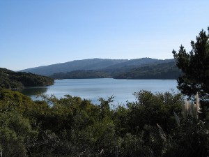
Water is very important in the Great Plains. In San Francisco, the water is monitored by the San Francisco Public Utilities Commission Natural Resources and Land Management Division. The divison is responsible for the management of 63,000 acres of watershed lands. The lands contain the water supply storage, transmission and treatment systems.


The Great Plains has extreme weather that includes tornados and hail. Unlike the Great Plains, San Francisco's climate is influenced by the cool ocean breeze which keeps the area cool. There is little temperature change in San Francisco.

Chapter 11: The Agricultural Core

The Agricultural core is located in the Midwest and the Bay Area is located in the West coast. The West Coast includes California, Oregon, and Washington.


The Soil type in the Bay Area does not include the two types of soils, mollisols and alfisols, found in the Agricultural Core. The main reason why the Bay Area does not include mollisols and alfisols is because the climate does not accomodate to form them. There are 5 soil types in the Bay Area. The 5 soil types have been defined as A, B, C, D and E by the National Earthquake Hazards Reduction Program. They include unweathered intrusive igneous rock, volcanics and Mesozoic bedrock, sandstone, mudstone, limestone and artificial fill.


Chapter 10: the southern coastlands: On the Subtropical Margin


The southern coastland of the Bay Area would include the San Mateo and Santa Cruz counties. The southern coastland has a subtropical environment and the Bay Area has an environment similar to Washington or Oregon.


Florida is known as an area where a lot of people like to go and retire. People over the age of 60 have populated 22% of Florida. Unlike Florida, the Bay Area does not have a large percentage of elderly people. This is projected to change in the future because it is projected that by the year 2020, the elderly population aged 60 and over will be a percentage increase of 50-99%.


In the 18th and 19th centuries, lemons were increasingly planted in Florida and California (www.allcolorsofnature.com). The textbook Regional Landscape of the United States and Canada, mentioned that California produces more lemons than Florida. Lemons are not grown in San Francisco, but they are grown in near by Joaquin Valley.


Chapter 9: The Changing South


Unlike the south, San Francisco does not have any plantations, but there is an abundance of crops, such as the vineyards of Sonoma County, and the garlic of Gilroy in Santa Clara County. Slavery was abolished with the passing of the 13th Amendment in 1865. California was not considered a slavery state and was offered a safe haven because it was a free state. After slavery was abolished many migrated out of the south and into other regions of the United States, including California. What attracted them to the bay area were the abundant labor opportunities, and the economic diversity. The bay area also offered a pleasant place to live in because of the weather and the sorrounding beaches and ports. The bay area was also not effected by the dust bowl.

Chapter 8: Appalachia and the Ozarks

San Francisco does not compare to the forestry and rugged terrain of the Appalachia and the Ozarks. Twelve miles from San Francisco, there is a preserved forest called the Muir Woods National Monument. It is the closest forestry near San Francisco. Muir Woods is the home of the tallest tree, the Coast redwood, Sequoia sempervirens.

Source:
wikipedia.org/wiki/Muir_Woods_National_Monument


Another place near San Francisco is the Calaveras Dam, located at the Alameda-Santa Clara County line. The dam and resevoir is owned by the city and county of San Francisco. The dam is a 230 foot high barrier which holds the largest drinking water reservoir in the 9 county region. Since its location is on an active fault zone, dam regulators drained the reservoir to about a third of its capacity.

source:


Chapter 7: The Bypassed East

The Bypassed East is cold, receives a good amount of precipitation, and is mountainous.The Bypassed East and San Francisco are similar except for the mountains. San Francisco averages 57.3 degrees Fahrenheit annually. San Francisco has an annual average precipitation of 22.28 inches with the wettest month being in January with 4.72 inches (www.idcide.com). Among major U.S. cities, San Francisco has the coldest daily mean, maximum, and minimum temperatures for June, July and August.


The Bay Area is in a high traffic, high population location it would be hard to set up a farm close to the City. According to the San Francisco Urban Agriculture Alliance, San Francisco is at the forefront of urban agriculture in America.  The City is working on legislation to permit urban gardens in all areas of San Francisco and the sale of all produce grown in those gardens. Some factors that prevent the Bay area from having a lot of agriculture are that it is covered with buildings and there is high pollution. Solano County and Sonoma County are places in the Bay area that have agrucultural land.

Chapter 5: The North American Manufacturing Core

San Francisco is not part of the North American Manufacturing Core, but there is still some employment in manufacturing present in San Francisco. The location of San Francisco means that there should be an easily flow with the means of transportation and communication. The railway system is the Bay Area Rapid Transit (BART) which helps people commute in and out of the City. The central part of BART is San Francisco of course because of all of the office space that dominate the financial districts.


 Some famous manufacturing include: Levi's Jeans, New United Motor Manufacturing, Inc. (NUMMI) was built by General Motors and used to manufacture cars such as the Chevy Nova, Geo Prism, and Toyota Corolla.

Chapter 4: Megalopolis


Megalopolis is region made up of several small cities and their surrounding areas in sufficient proximity to be considered a single urban complex (Regional Landscapes of the United States and Canada). The Megalopolis that stretches the California coast from the San Francisco Bay area to Sand Diego is known as SanSan. One of the reasons that characterizes San Diego as a megalopolis is that it has the San Francisco Bay which is easily navigable for ships, Port of San Francisco which has been considered a natural harbor, and the Bay is spanned by six bridges (Golden Gate, Bay Bridge, San Mateo Bridge, Dumbarton, Richmond-San Rafael Bridge, and the Carquinez). Another reason is with the Pacific Ocean as a route to Asia, the Bay Area has been a stop for freight liners to drop off their cargo. San Francisco serves as the regional hub for many arms of the federal bureaucracy, including the U.S. Court of Appeals, the Federal Reserve Bank, and the U.S. Mint.


Source:
http://en.wikipedia.org/wiki/San_Francisco


Chapter 3: Foundations of Human Activity


 The Yelamu group of the Ohlone people resided in several small villages when a Spanish exploration party, led by Don Gaspar de Portolà arrived on November 2, 1769, the first documented European visit to San Francisco Bay. Seven years later, on March 28, 1776, the Spanish established the Presidio of San Francisco, followed by a mission, Mission San Francisco de Asís. Despite its attractive location as a port and naval base, San Francisco was still a small settlement with inhospitable geography.

When the Gold Rush hit California, San Francisco was a port of entry for people who came to the area to try and find gold. The Gold Rush propelled the city into a period of rapid growth which transformed the city into on of the largest city in the west coast at that time.


After World War II, the confluence of returning servicemen, massive immigration, liberalizing attitudes, and other factors led to the Summer of Love and the gay rights movement, cementing San Francisco as a center of liberal activism in the United States.

Source:
http://en.wikipedia.org/wiki/San_Francisco

Chapter 2: Geographic Patterns of the Physical Environment

San Francisco is surrounded on three sides by water which causes the weather to be strongly influenced by the cool currents of the Pacific Ocean. Because of its sharp topography and maritime influences, San Francisco exhibits a multitude of distinct microclimates.Many types of rocks and soils are found in San Francisco, like sedentary rocks of sandstone, limstone, and shale in uplifted seabeds, coal deposits, and igneous forms such as basalt flows, and ash deposits of extinct volcanoes. San Francisco is known for its hills because there are over 50 hills within the city limits. The tallest hill in San Francisco is Mount Davidson which is 925 feet high.

Source:
http://en.wikipedia.org/wiki/San_Francisco

Chapter 1: Regions and Themes

San Francisco, Ca is located in the southwest of the united states and icludes stretches along the Pacific ocean and San Francisco Bay. San Francisco is the financial, cultural and transportation center of the San Francisco Bay area. San Francisco is compossed of 10 districts and 27 different neighborhoods. The city in the principal banking and finance center which helps the city be ranked eighteenth in the world's top producing cities. According to the 2010 United States census, the population is San Francisco is 805,235 that includes a diverse racial make up.

Source:
http://en.wikipedia.org/wiki/San_Francisco